If you want a picture of how climate change is affecting our weather here in New England, you need look no further than the spring we’ve just had. It’s been a grim reminder of how climate change is taking us to new extremes that defy the seasons, upset crop-growing patterns, and even foul the air we breathe.
And the official start of summer isn’t even here yet! Here’s a quick look at four important climate events from the Spring of 2023 – and a look ahead.

An early-spring heat wave starting on April 13 brought 90-degree temperatures to Manchester, NH, and much of New England, launching an early blossom of fruit trees, plants and flowers.
Early Heat
Before spring even got started this year, let’s recall that the first three months of 2023 were the second warmest on record in New Hampshire and Vermont, running a full 7 degrees F hotter than the 20th century average. (January 2023 was the warmest on record – running more than 12°F above the monthly average!) Such mild winter weather thawed the soils and prepped the trees for an early start to spring.
And, boy, did we get it! An early-season heat wave spread over New England on April 13 that shattered temperature records all over the region. Over the next four days, daily high temperatures climbed well into the 80s and even the low 90s in Vermont and New Hampshire. The Manchester, NH, airport reached 91°F on April 14, smashing the old record set in 1949 by a whopping 14 degrees. That same day, Hanover, NH, broke a 55-year old record by 6 degrees, set in 1968, with an 86°F reading.
The story was much the same in Vermont. The Burlington airport reached 88°F on April 14, smashing a 78-year old record set in 1945. Even Mt. Mansfield got in on the act, setting four consecutive daily high temperature records on April 13-16 – even eclipsing the 70-degree mark for the time ever on two of those dates. Altogether, 50 new daily high temperature records were tied or broken at weather stations in Vermont and New Hampshire over that four-day period, sending a tantalizing signal that the spring growing season was open and ready for business.

A late-spring cold snap starting on May 17 brought below-freezing temperatures to Manchester, NH, and as far south as Connecticut, zapping trees and plants that had started to blossom a month before.
Late Frost
Fast forward into May 2023, and our weather story was completely reversed. Over a four-day period starting on May 17, 21 new daily low temperature records were tied or set in Vermont and New Hampshire. With an Arctic plunge of frigid air that covered most of New England, the Lebanon, NH, airport recorded a hard frost on May 17, dropping to 28°F. Meanwhile, the mercury in Morrisville, VT, dropped all the way to 25°F. Both towns set daily low-temperature records.
If that was not enough to damage tender crops that had started to bloom, the following two nights added insult to injury. The overnight low in Rutland, VT, on May 18 dropped to 25°F, eclipsing a 40-year old low-temperature record set in 1983. Keene, NH, suffered a similar fate that night, with a hard freeze of 24°F that smashed a 90-year old record. At the northern end of the state, Colebrook, NH, recorded 19°F overnight readings on May 18-19, both records, while Mt. Washington dropped all the way to 10°F on May 19, setting its own bone-chilling record for that date. Even parts of Connecticut were touched by killing frost on those two nights.

Brown buds on this apple tree are a sure sign that it fell victim to frost and won’t bear fruit this year. Oak and beech trees didn’t fare much better, leaving most New England forests short of food and forage for the upcoming winter season. Photo by Glenn Russell/VT Digger
Lost Harvest
This spring’s false start has been devastating to flowers and fruit blossoms that had started to bloom after April’s early-season heat wave. Most apple orchards south of Rt. 2 in Vermont and New Hampshire reported heavy to complete losses of this year’s harvest. In Vermont, total fruit losses – including for blueberries, grapes, peaches and stone fruits – may surpass $10 million among 40 large orchard growers. This doesn’t include secondary losses that some growers will sustain, like selling cider, jams and donuts to customers that pack their orchards during the fall harvest season.
In a recent appeal for federal disaster relief, Vermont’s Secretary of Agriculture Anson Tebbetts minced no words.
“Right now, growers are assessing their ability to stay in this industry,” he wrote. “Unfortunately, many orchards, produce operations, and vineyards are either uninsured or under-insured and insurance claims are unlikely to cover the total business loss from crop damage and reduced revenue from value-added products. Without aid we will see devastating blows to local economies because of downsizing and closing businesses.”
It could be a tough winter season for wildlife as well. That’s because May’s killing frost also did unusual harm to red oak and beech forests in New England that were also in the process of leafing out. Now, a month after the freeze, hillsides throughout our region have taken on a rust-colored hue, adorned with burned-out oak and beech leaves that will hang lifeless throughout the summer. Come fall, very few acorns and nuts will fall for foraging animals as they get ready for winter. Black bears, in particular, may roam farther afield in search of food around their winter hibernation.
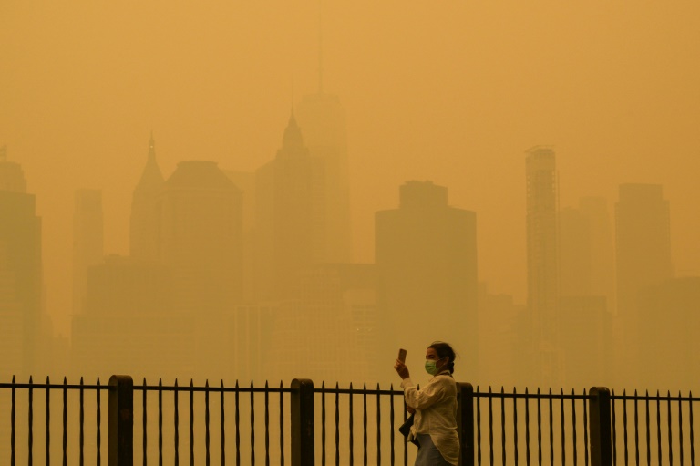
Smoke from Canadian wildfires virtually blocked out the sun over New York City on June 7.
And Now Smoke
As if we didn’t have enough things to complain about, smoke has emerged as another topic of daily weather conversation. We first reported about this phenomenon in a blog posted on May 17, when wildfires in western Canada sent a plume of smoke wafting across the jet stream continent to reach the eastern United States. Since then, new wildfires have erupted in Quebec and Nova Scotia with much shorter distances for smoke to travel before reaching our region.
Fortunately, northern New England has been spared the worst of this latest onslaught. That’s because of another unusual weather phenomenon that has set up off the coast of New England: a cut-off low pressure system that has acted like a weather barrier and steered the heaviest wildfire smoke to our west and south. As a result, we have managed to dodge the bullet from this smoking gun (well, at least so far!).
For a time in early June, New York City was in the crosshairs, sporting some of the worst air quality of any major city on Earth. On June 7, just breathing outdoor air in Central Park was like smoking a cigarette for every hour spent outdoors. New Yorkers were urged to limit their time outside, and the elderly, infants and those with respiratory ailments were told to stay indoors until the smoke cleared. Eventually, this thick plume reached Philadelphia and Washington, DC, though in slightly less-toxic concentrations.

As of mid-June, more than 400 wildfires were raging across western and eastern Canada. The peak of Canada’s wildfire season isn’t until July.
A Quick Look Ahead
Looking ahead, there is no real let-up in sight for Canadian wildfires this summer. Already, more acreage has burned than in any previous year. With more than 5.2 million hectares (13.6 million acres) already burned as of June 13, the devastated areas cover a land mass larger than the states of Vermont and New Hampshire combined. The height of the Canadian wildfire season isn’t until July.
Unlike California and parts of the western United States that were blanketed with heavy snow this winter, most of Canada has been in a snow drought this year. From British Columbia to the Maritime provinces, early snowmelt and dry spring conditions turned trees to tinder. Spring thunderstorms then set them ablaze.
As of this writing, more than 460 forest fires are raging across Canada, nearly half of which are still burning out of control, according to the Canadian Interagency Forest Fire Centre. More than 100,000 people have been evacuated in nine provinces across the country, with wildfire flames nearby. Warm, dry conditions driving these fires are expected to continue in nearly every Canadian province and territory throughout the summer.
More than 600 firefighters from Europe have responded to Canada’s call for international help, issued on June 7. Firefighters from the United States and as far away as Australia, Chile, Costa Rica and South Africa have also answered the call.
Closer to home, persistent cool, wet weather has kept both local wildfires and Canadian smoke mostly at bay. On June 4, in fact, nine weather stations in New Hampshire recorded their lowest maximum temperature ever for that date. In Nashua, the mercury reached only 51 degrees, shattering a record that set just five years before by a frosty 8 degrees.

Although temperatures in New England are running well below average so far this June, the 90-day weather forecast calls for a return to above-normal temperatures in July and August, along with a heightened risk of wildfires in New Hampshire, Vermont and the Adirondacks of New York.
Once this weather pattern breaks, a return to warmer weather is forecast throughout New England and all along the East Coast of the United States. At the same time, El Niño conditions are setting up in the Pacific Ocean, which normally brings warmer temperatures across much of the globe. On top of that, ocean waters where Atlantic hurricanes form are running more than 2°F above normal this year.
This is making the 2023 hurricane season especially volatile and difficult to forecast. Typically, El Niño conditions cause wind shear and cooler sea surface temperatures in the Atlantic Ocean, which puts a crimp on hurricane development. However, this year, all bets are off because of this highly unusual combination of very warm water in both the Pacific and Atlantic basins. A persistent weak high-pressure ridge off the East Coast of the United States could steer any hurricanes reaching the coast to drift north toward New England.
With all of the strange weather events and off-the-charts records being set in New England so far this year, perhaps the safest forecast is simply to expect more of the unexpected this summer!
Unfortunately, an even better long-term bet is that the weather will only get wilder and wackier until fossil fuel emissions contributing to climate change are taken out of our air.
That’s where Solaflect Energy comes in. For 15 years, we have been your trusted home energy management partner. We help you install clean and affordable solar electricity for a more resilient and climate-friendly future. For more information email us, or call (802) 649-3700. Working together, we have the power to make a difference in the fight against climate change.

