Climate change is full of surprises, and sometimes they can be pleasant. The string of cloudless and smoke-free days during this first week of October may be payback for the dank and stormy conditions that brought record floods and rainfall to New England this summer. Regardless, this warm and sunny spell has been an auspicious end to a tumultuous summer when temperatures actually got higher in April and October than they did in August, and a late-killing frost nipped blossoming trees in the bud just before Memorial Day weekend.
In short, recent weather trends are breaking the mold. And sometimes they aren’t so pleasant! Now, virtually any rainstorm holds the specter of turning extreme. It’s as if we’ve entered a “climate change lottery” where something calamitous might occur on any given day, depending on where you live and if your number happens to come up. Unfortunately, there’s no “safe haven” anymore!
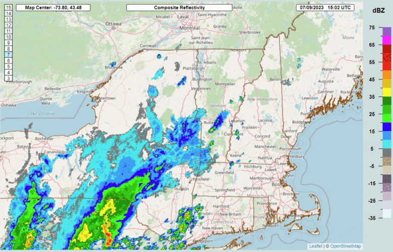
Catastrophic flash flooding and river flooding struck Vermont on July 9-11, with the highest 48-hour rainfall total reaching 9.20 inches in Calais, Vermont. An atmospheric river dropped 4 to 8 inches of rain along the spine of the Green Mountains and adjacent communities, surpassing rainfall totals from Tropical Storm Irene in 2011. – U.S. National Weather Service
Rain, Floods and Hurricanes
Chances are, you may have already forgotten about Hurricane Lee. However, for two weeks in early September, this powerful ocean storm kept the Eastern Seaboard on high alert as it crept up the coast and briefly gained Category 5 strength, before weakening into a tropical storm and making landfall in Nova Scotia on Sept. 16. Parts of Downeast Maine received a half-foot of rain and briefly lost power, as the storm wrung itself out over the Canadian Maritimes. But that’s no big deal by today’s climate-changing standards.
Fast forward two weeks and remnants of Ophelia – a run-of-the-mill tropical storm which never gained hurricane strength – managed to bring record flooding to New York City, catching weather forecasters by surprise. Subways flooded. Highways closed. Train service was suspended. Even a terminal at LaGuardia Airport had to close due to flash flooding, while nearby JFK Airport set a one-day record of 8.65 inches of rain, surpassing the September daily rainfall record set by Hurricane Donna in 1960. All because remnants of a forgettable tropical storm hooked up with an ordinary low-pressure system to turn into something extraordinary.
At least New York City’s flood had links to a named tropical system. There was no such storm to track when Leominster, Massachusetts, was suddenly devastated by flooding on Sept. 11. An unprecedented 11 inches of rain fell in just five hours. That’s more rain than fell in Vermont during Tropical Storm Irene in 2011 or in New York City – washing away roads, flooding downtown shops, and prompting a federal disaster declaration.
July’s flood brought the Winooski River in Montpelier to its highest level since 1927 (before a flood control dam was built). The downtown area is still recovering, with unresolved questions about its long-term climate resiliency.
Leominster’s flooding, in fact, was eerily reminiscent of the historic flooding that struck Vermont earlier this summer. No named storm was associated with this event, either, yet it managed to produce rainfall totals exceeding 8 inches on July 9-11 over a wide swath of the Green Mountains extending from Ludlow to Montpelier. While property losses are still being tallied – led by major flooding in downtown Montpelier and Barre – this storm joined a long list of billion-dollar natural disasters that have struck the United States this year. While most do not have a tropical connection, many of these disasters still got their start from record-warm Atlantic and Gulf Stream waters, creating high dew points and humidity levels in the air above. For mountainous New England, this sets up the right conditions for an “atmospheric river” to dump copious amounts of rain over our region, flooding towns and roadways below.
As a result, Vermont’s epic flood joined the list of 23 billion-dollar natural disasters that have struck the United States so far this year, already breaking an annual record set back in 2020. In fact, more than half of these disasters were spawned by severe thunderstorms, tornadoes and flash flooding that don’t qualify as “named” storms. But their consequences have been just as devastating – and sometimes their rainfall totals have been even more impressive and historic.
Flash Flooding Has a Common Source – Warming Oceans
As discussed in a recent post, a common denominator in many of these storms is rising ocean temperatures, which is extending “tropic-like” weather conditions beyond mid-latitudes of the globe to regions like the North Atlantic and Mediterranean Sea. This moisture-laden atmosphere is magnifying the effects of ocean storms as they combine with land-based weather systems, often producing sudden bursts of torrential rainfall over short periods of time. This combination is one of the main causes of flash flooding, which takes into account not just how much rain is falling, but how fast!
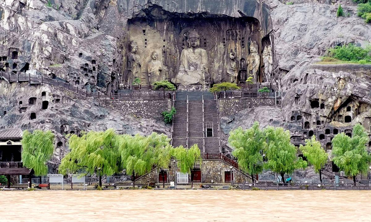
The Shaolin Temple in central China was closed due to flooding after record rainfall hit the Henan Province on July 20.
Here are some global examples of record flash flooding since July:
- On July 20, unprecedented rainfall triggered severe floods and landslides in several provinces of central China, affecting more than 10 million people. Zhengzhou, the capital city of the Henan province, recorded two feet of rain in just 24 hours, a one-day record that’s equal to its entire average annual precipitation! The flooding reached cultural sites like the Shaolin Temple and Longmen Grottoes that date back some 1,700 years.
- In mid-August, Chile’s central region received 14.5 inches of rain from an atmospheric river that formed over the Pacific Ocean. This caused major flooding, mudslides, and evacuation of some 30,000 people and was the second major flood event to strike the region this summer. Similar weather conditions also caused widespread flooding in late June, as ocean-warming El Niño conditions set up over the eastern Pacific Ocean.
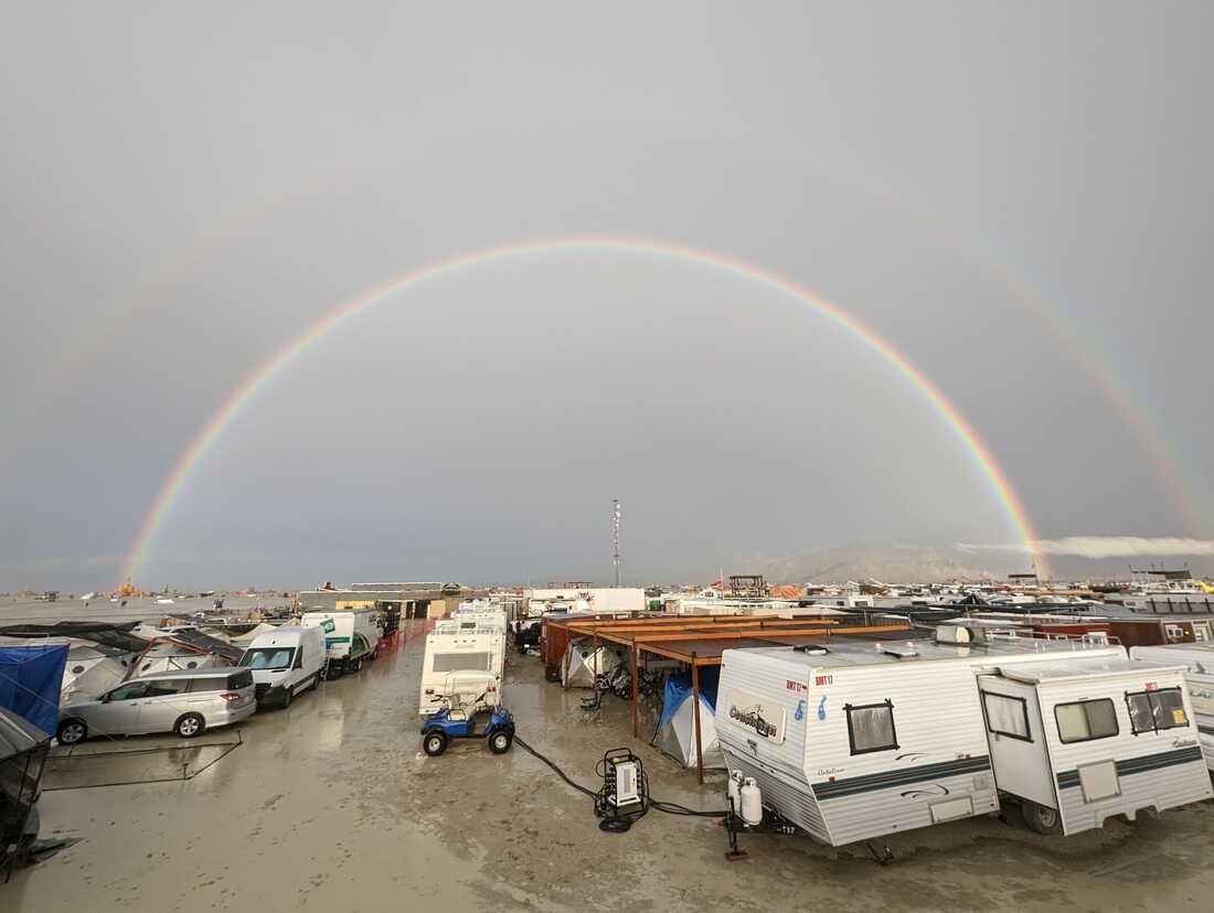
Burning Man festivalgoers had to wallow in the mud for several days before getting the all-clear to leave the remote desert site on Sept. 4.
- On Sept. 1, 70,000 participants at the Burning Man festival in the Black Rock desert of northern Nevada became stranded in the mud for several days after a heavy downpour dropped an inch of rain in just a matter of hours. That may not sound like much, but it’s as much rain as this desert area normally receives in two to three months. This highly unusual storm came from remnants of Tropical Storm Hilary, the first tropical storm to strike America’s west coast since 1997.
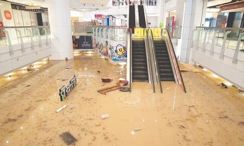
The worst flooding in Hong Kong in 140 years brought most of the city to a halt on Sept. 8, including this shopping center and subway station.
- On Sept. 7-8, Hong Kong recorded nearly 25 inches of rain, including 8 inches in a one-hour period, the highest hourly rainfall rate since records began in 1884. Like the storm that brought record rainfall to New York City later in the month, this deluge was caused by remnants of a tropical storm that folded into a low-pressure system. Weather forecasters saw this one coming; they issued their highest “black storm” warning for the first time in nearly two years. As a smart precaution, bus and subway service was suspended, schools were closed and trading was halted on the Hang Sang stock exchange.
- There was no such warning when Derna, Libya, received 16 inches of rain in a 24-hour period on Sept. 16. That’s five inches more than this city of 150,000 people normally receives in an entire year! Making matters much worse, two poorly maintained dams failed, unleashing a 23-foot wall of water that tore through the middle of the city, killing 6,000 and leaving 9,000 others still missing, making this the most lethal weather disaster of the summer.
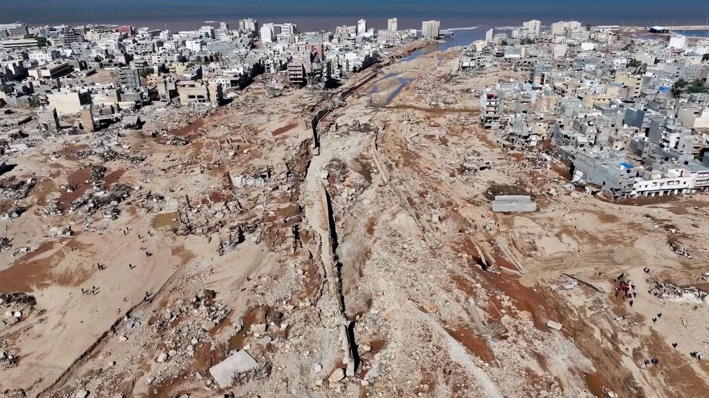
Torrential rain from “Medicane” Storm Dennis caused two poorly maintained dams to fail near Derna, Libya, washing away entire city neighborhoods and sweeping residents into the sea.
- Just days earlier, this same Mediterranean storm – dubbed a “Medicane Daniel” because of its hurricane-like ferocity – had drenched parts of Greece, Turkey and Bulgaria. Central Greece, which had been skirting wildfires all summer, received as much as 30 inches of rain on Sept. 5, a single-day record for Greece, including 21 inches that fell in just a 10-hour period! Yet another Mediterranean storm — “Medicane Elias” – struck Greece in the last week of September. Velos, a city of about 140,000 people, received nearly 12 inches of rain on Sept. 24 – 10 times its monthly average for September!
- Finally, in late September, South Africa’s Western Cape province was raked by severe storms that caused the region’s worst flooding in perhaps 100 years. Torrential rains closed major routes into Cape Town, a coastal city of four million people, and damaged crops, bridges and other infrastructure. While this low-pressure system was not unusual, its setup caused local weather forecasters to issue their highest-level warning for residents of the Western Cape, calling for “rapid heavy downpours, excessive lightning, strong downdrafts as well as large amounts of small hail.” This warning sounded much like forecasters’ first-ever use of “extreme risk” to describe the epic flooding that was coming Vermont’s way on July 9-10.
All of this is a solemn reminder to heed these weather warnings and recognize that any given storm now might produce a hurricane’s worth of rain and flood damage in this new era of global warming.
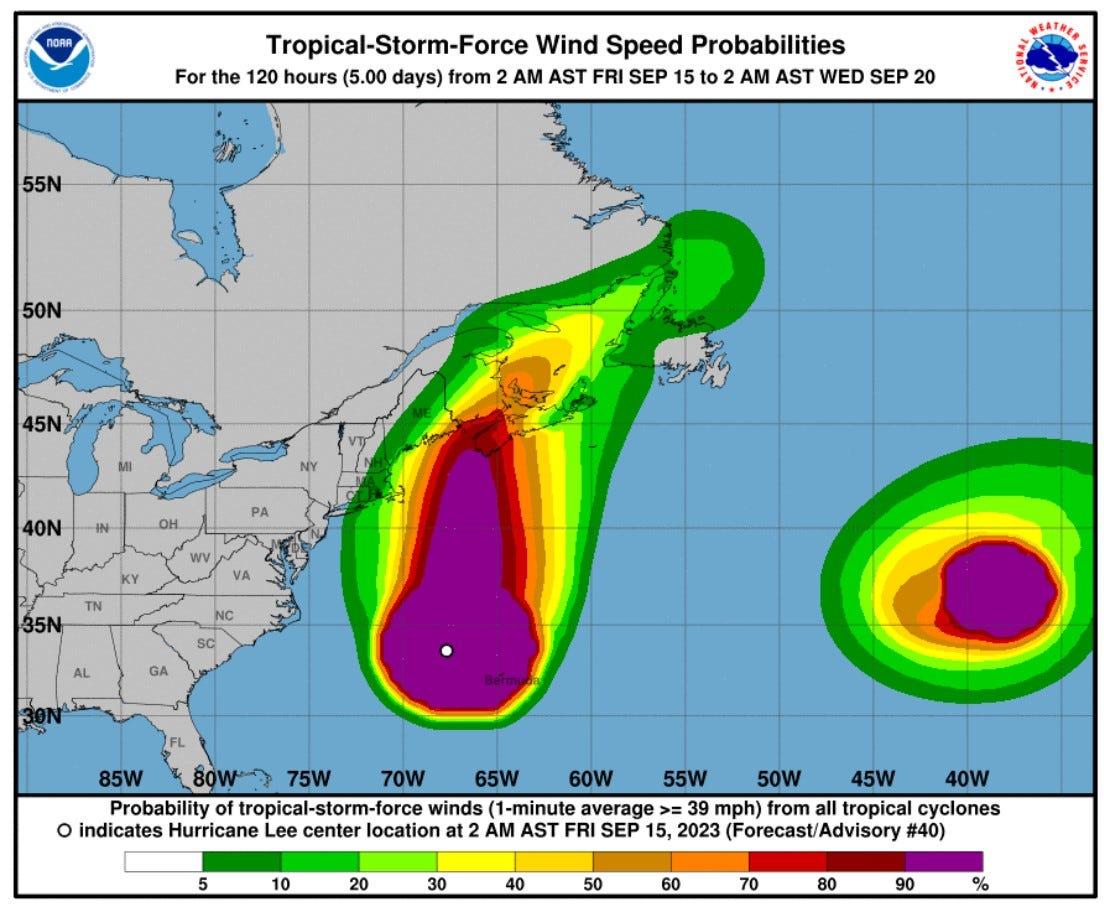
Despite 10 days of forecasting and anticipation of landfall, Hurricane Lee ended up with much less rain and damage than some unnamed storms that caused catastrophic flooding in New York and New England this summer.
Solaflect Trackers Stand Up to Climate Change
Solaflect Trackers are built to weather these increasingly severe storms. Our solar arrays are secured with high-tension cable suspension systems and feature dual-axis tracking to withstand high winds. They also have high ground clearance and buried concrete mounts to avoid flooding and the buildup of snow in the wintertime.
Technology for climate change adaptation is one thing. Technology that actually mitigates climate change is another. Our Solar Trackers replace natural gas and other dirty fuels from the grid with pure sunshine that’s collected in your own backyard. And our new Solar EV Chargers replace gasoline and diesel fuel with solar power in workplace parking lots and other locations where the methane “natural gas”-fueled grid, and associated EV charging is more expensive and harder to manage. And when the grid is out due to storm damage, our Solar EV Chargers are still up and running, tracking the Sun, and providing climate-resilient power for those who lease or own them.
Solaflect Energy is your home energy management partner. We offer sun-tracking solar arrays for residential use and off-grid Solar EV Chargers for employee EV charging during the workday. Check out www.solaflectev.com for Solar EV Charging, or email us or call (802) 649-3700 to learn more about all our solar options. Working together, we can make a difference in the fight against climate change – and reduce the high cost of energy in our own communities!

